Burch ell’s zebras and blue wildebeests roam Serengeti National Park in Tanzania, one of the last places in Africa where large animal migrations still occur. During the wet season herds with numbers in the thousands populate the southeastern plains of the park. In the dry season the animals migrate westward into the woodland savanna of the Serengeti and northward to the grassland areas of neighboring Kenya. Serengeti National Park is an important tourist attraction for Tanzania, one of the world’s least developed countries. Serengeti National Park, park in northern Tanzania. Established in 1941, the park covers 14,800 sq km (5,700 sq mi) and consists mainly of flat, open grassland, with a few rocky kopjes (small hills) and some areas of woodland and bushy savanna in the western part of the park. The Serengeti is the only national park in Africa where seasonal migrations of plains animals take place. Serengeti National Park is inhabited by more than 200 species of birds and 35 species of plains mammals, including cheetahs, leopards, lions, and giraffes. Zebras, gnus (large African antelopes also called wildebeests), gazelles, and elephants did not exist in large numbers in the park until the 1960s, when the rising human population in the region caused a shortage of natural resources and forced many of these animals into the protected area. About 200,000 zebras, 2 million gnus, 1 million gazelles, and thousands of elephants now live in the park. The plains of Serengeti National Park are also home to black rhinoceroses. During the rainy season, from November to May, millions of animals graze on the park's southeastern plains. This area has few rivers and becomes excessively dry once the rainy season ends, so gnus, gazelles, and zebras migrate to the western savanna and as far north as the grasslands of Masai Mara Game Park, across the Kenya-Tanzania border, where they spend the dry season. In addition to the migration of ungulates, the park is well known for its healthy stock of other resident wildlife, particularly the "big five", named for the five most prized trophies taken by hunters: Masai lion: the Serengeti is believed to hold the largest population of lions in Africa due in part to the abundance of prey species. More than 3,000 lions live in this ecosystem. African leopard: these reclusive predators are commonly seen in the Seronera region but are present throughout the national park with the population at around 1,000. African bush elephant: the herds are recovering from population lows in the 1980s caused by poaching and are largely located in the northern regions of the park. Eastern black rhinoceros: mainly found around the kopjes in the centre of the park, very few individuals remain due to rampant poaching. Individuals from the Masai Mara Reserve cross the park border and enter Serengeti from the northern section at times. African buffalo: still abundant and present in healthy numbers. This park also supports many other species, including the Thomson's and Grant's gazelle, wildebeest, topi, eland, waterbuck, spotted hyena, striped hyena, serval, baboon, impala, East African wild dog, and Masai giraffe. It also boasts about 500 bird species, including ostriches, secretary bird, kori bustards, crowned cranes, marabou storks, martial eagles, lovebirds, and many species of vu

KILIMANJARO NATIONAL PARK
Kilimanjaro National Park covering an area of some 75,575 ha protects the largest free standing volcanic mass in the world and the highest mountain in Africa, rising 4877m above surrounding plains to 5895m at its peak. With its snow-capped peak, the Kilimanjaro is a superlative natural phenomenon, standing in isolation above the surrounding plains overlooking the savannah. Criterion vii: Mount Kilimanjaro is one of the largest volcanoes in the world. It has three main volcanic peaks, Kibo, Mawenzi, and Shira. With its snow-capped peak and glaciers, it is the highest mountain in Africa. The mountain has five main vegetation zones from the lowest to the highest point: Lower slopes, montane forest, heath and moorland, alpine desert and summit. The whole mountain including the montane forest belt is very rich in species, in particular mammals, many of them endangered species. For this combination of features but mostly its height, its physical form and snow cap and its isolation above the surrounding plains, Mount Kilimanjaro is considered an outstanding example of a superlative natural phenomenon. 75,000 people climb Kilimanjaro every year so it is not the most untouched mountain, nor is it the most arduous. However, it is certainly a test of one’s endurance, with altitude sickness the main reason for climbers not to summit. Although it has become a very popular challenge and the experience slightly crowded with other climbers, we still highly recommend it for anyone with even a vague interest in mountaineering. INTEGRITY Kilimanjaro National Park, established in 1973, initially comprised the whole of the mountain above the tree line and six forest corridors stretching down through the montane forest belt. At the time of inscription in 1987, the main pressures affected mostly the forest reserve which acted as a buffer zone to the park. The World Heritage Committee recommended extending the national park to include more areas of montane forest. Following a 2005 extension, the National Park includes the whole of the mountain above the tree line as well as the natural forest (montane forest) which was under Kilimanjaro Forest Reserve, and as such fulfils the criteria of integrity. It is important that the extension of the National Park be reflected in the boundaries of the property. The wildlife of the property is important to the experience of Kilimanjaro, although the property is not inscribed in relation to biodiversity criteria. Pressures on elephant, buffalo and antelope, and logging in the Forest Reserve area, were noted as integrity concerns at the time of inscription. The park is connected to Amboseli National Park, however corridors to Arusha National Park and Tsavo National park have been encroached, impacting

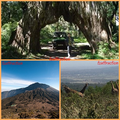
MOUNT MERU
Mount Meru, extinct volcano in northeastern Tanzania, about 68 km (42 mi) west of Kilimanjaro. After Kilimanjaro, it is the second highest mountain in Tanzania at 4,565 m (14,977 ft). Rain forest and bamboo comprise the major vegetation between 1800 and 2900 m (5900 and 9500 ft) above sea level, which then gives way to alpine grassland. Volcanic soil and heavy rainfall, especially on the southern and eastern slopes support agriculture. Bananas and coffee are the main crops. By contrast, the northwestern and northern slopes of the mountain are barren. The Meru, a Bantu-speaking agricultural people for whom the mountain was named, have long populated the southern and eastern slopes up to 1800 m (5900 ft). Arusha, an important commercial and administrative center, lies at the mountain's southern base. Mt. Meru is located in the heart of Arusha National Park This trek serves as an ideal warm up for Mt. Kilimanjaro due to its altitude acclimatization and hiking distances. This trek is also geared towards hikers that prefer less crowds and a challenging ascent. Because
Mt. Meru is located in Arusha National Park, hikers must climb with an armed ranger due to the wide range of wildlife living on the mountain. On the lower slopes of the mountain, hikers are more likely to see elephants, giraffes, and buffalo! As hikers continue their ascents, the trail follows the north rim of the volcano’s crater along a dramatic ridge line. Throughout the climb, hikers sleep in designated huts along the trail. Hikers reach the summit as the sun is rising and they will have spectacular views of Mt. Kilimanjaro and of the Mt. Meru Crater. NOTE: Mountain Climbing Permits duration time is 12 HOURS.
Where is Mt Meru and how big is it? Size: 552 sq km 212 sq miles).
Location: Northern Tanzania, northeast of Arusha town..
How to get to Mt Meru in Arusha National Park An easy 40-minute drive from Arusha. Approximately 60 km (35 miles) from Kilimanjaro International Airport. The lakes, forest and Ngurdoto Crater can all be visited in the course of a half-day outing at the beginning or end of an extended northern safari. NOTE: Mountain Climbing Permits duration time is 12 HOURS.
What to do in Mt Meru Forest walks, numerous picnic sites; Three- or four-day Mt Meru climb – good acclimatization for Kilimanjaro.
When to Climb Mt Meru To climb Mt Meru, June-February although it may rain in November. Best views of Kilimanjaro December-February.


LAKE MANYARA NATIONAL PARK
Lake Manyara NP is a small park at the base of the Rift Valley escarpment. Its groundwater forest offers a nice change of scenery from the more savannah dominated parks. Although the park is known for tree-climbing lions, big cats aren't that easily seen. Elephants are very prolific and are the main attraction. Size:(330 km²) or( 130 mi²) Altitude:(953-1445 m) or( 3127-4741 ft) Pros and Cons • Very relaxed elephants to view at close quarters • Stunning scenery • Superb birding and seasonal flamingo flocks • Close to Arusha and on route to Ngorongoro crater and Serengeti • Has species less common or more difficult to see in other northern parks • Rarely visited in the morning • Gets crowded in the afternoons during peak season (June and July and October to April)
WILDLIFE This park is known for its large elephant population. The big cats are present, but not seen that easily. The forest patch is home to habituated troops of olive baboon and blue monkey. Buffalo, giraffe and several antelope species are easily encountered on a drive. More about Manyara's wildlife Sc
enery (surrounding)
Lake Manyara is a shallow alkaline lake at the base of the Western Rift Valley escarpment. The park entrance leads to a beautiful groundwater forest. Other habitats include the grassy floodplain, rocky escarpment and acacia woodland, all of which can be covered in a half-day visit Getting there By road, charter or scheduled flight from Arusha, en route to Serengeti and Ngorongoro Crater.
What to do
Game drives, night game drives, canoeing when the water levels is sufficiently high. Cultural tours, picnicking, bush lunch/dinner, mountain bike tours, abseiling and forest walks on the escarpment outside the park.
When to go
Dry season (July-October) for large mammals; Wet season (November-June) for bird watching, the waterfalls and canoeing.
Accommodation
One luxury tree-house-style camp, public bandas and campsites inside the park. One luxury tented camp and three lodges perched on the Rift Wall outside the park overlooking the lake. Several guesthouses and campsites in nearby Mto wa Mbu.

ARUSHA NATIONAL PARK.
About Arusha National Park
Though very accessible, Arusha NP isn't on many safari itineraries. This is mainly because it doesn't offer a chance of seeing the Big Five. The park is at the base of Mount Meru, which is good for climbing. It has a range of habitats including forest - home to black-and-white colobus monkeys - and is excellent for birding. Size: help(552 km²) or( 212 mi²)Altitude:(1340-1839 m / )or(4396-6033 ft)
Pros and Cons
• Very scenic with different habitats, including forest
• Views of Mount Kilimanjaro
• Excellent birding with about 400 species, including forest birds
• Close to Arusha and accessible for a day trip
• Canoeing safari is offered
• Off the beaten track and not crowded
• Most of the major safari animals aren't present or aren't easily seen
Wildlife
Game viewing in Arusha NP is more low-key than in the other parks in Northern Tanzania. Animals that are easily seen include buffalo, giraffe and several antelope species. More exciting are the black-and-white colobus monkeys that live in the forest, and the large number of bird species. Several lakes often host flocks of flamingos. Further north, rolling grassy hills enclose the tranquil beauty of the Momela Lakes, each one a different hue of green or blue. Their shallows sometimes tinged pink with thousands of flamingos, the lakes support a rich selection of resident and migrant waterfowl, and shaggy waterbucks display their large lyre-shaped horns on the watery fringes. Giraffes glide across the grassy hills, between grazing zebra herds, while pairs of wide-eyed dik-dik dart into scrubby bush like overgrown hares on spindly legs. Although elephants are uncommon in Arusha National Park, and lions absent altogether, leopards and spotted hyenas may be seen slinking around in the early morning and late afternoon More about Arusha NP's wildlife
Scenery (surrounding)
The park's appeal is mainly its scenery. The habitat diversity spans from montane rainforest to moist savannah to alpine moorland. The most prominent landmark is Mount Meru. Other highlights are a massive extinct volcano and several scenic lakes, with Mount Kilimanjaro in the background on a clear day.
Getting there
just 40-minute drive from Arusha. Approximately 60 km (35 miles) from Kilimanjaro International Airport. The lakes, forest and Ngurdoto Crater can all be visited in the course of a half-day outing at the beginning or end of an extended northern safari.
What to do
Forest walks, numerous picnic sites; three- or four-day Mt Meru climb - good acclimatisation for Kilimanjaro.
When to go To climb Mt Meru, June-February although it may rain in November. Best views of Kilimanjaro December-February.
Accommodation
Two lodges, two rest houses, camp sites, two mountain huts inside the park; more lodges at Usa River outside the park and many hotels and hostels in Arusha town.
Gombe National Park
Gombe, designated as a game reserve in 1943, was upgraded into a national park status in 1968. The park is located 16 km north of Kigoma town on the shores of Lake Tanganyika in western Tanzania. It covers an area of 56 square kilometers and is a fragile habitat for chimpanzee. Gombe gained its popularity after the research of Dr Jane Goodall which is believed to be the longest running study of primates in the world.
How to get there
By boat: Board public boat (up to four hours) or motor boat (two hours). The motor boat can be booked through or directly at the park information center located in Kigoma town.
TO GET TO KIGOMA:
By air: scheduled flights from Dar es Salaam and Mwanza cities or from Arusha by chartered flights.By rail: from Dar es Salaam or by ferry from Mpulungu in Zambia.By road: from Dar es Salaam, Arusha or Mwanza.
BEST TIME TO VISIT
Chimpanzee can be trekked throughout the year. However, for plants/insects and better chimpanzee spotting, the best time is during wet season (November to mid May) and for the best photo taking (May to October).
TOURISM ACTIVITIES
CHIMPANZEE TREKKING– This activity is conducted from 0630 – 1830 hrs. WALKING SAFARI –Short walks along the shores of Lake Tanganyika or to HIKING TO JANE’S PEAK VIEW POINT • This view point offers a spectacular view of the park and Lake Tanganyika. While at the view point one can hear chimpanzee calling and screaming. The hike takes about two hours from kasekela.
BIRDING
Over 200 birds species fly around, varying from the African crowned eagle that hunts monkeys, to the iconic fish eagle, three kinds of kingfisher and the bright Peters twins pots. Another remarkable character is the palm-nut vulture; a near-vegetarian common to Lake Tanganyika that prefers fruits over carcasses.
FILMING: Hugo van Lawick in 1988 filmed people of the forest – the chimps of Gombe.
.MAIN TOURIST ATTRACTIONS CHIMPANZEE The Chimpanzee are Sharing more than 98% of our genes, it’s a look of recognition from our closest animal relative. COLOBUS, RED-TAILED AND BLUE MONKEYS THE MAJORITY OF THE PARK’S MAMMALS ARE PRIMATES, most of them forest species. Likely to be seen, in addition to the famous chimpanzees, are the colorful red-tailed and blue monkeys. KAKOMBE AND MKENKE WATERFALL LAKE TANGANYIKA The longest and deepest lake in Africa which harbors about 350 species of fish, most of them endemic. The lake shore offers sun bathing and sunset viewing opportunities.
ACCOMMODATION:
Inside the park: Rest house and one luxury tented camp. Outside the park: In Kigoma town

MKOMAZI NATIONAL PARK.
Set below the verdant slopes of the spectacular Usambara and Pare Eastern Arc Mountain ranges and overseen by iconic snow – capped peak of Kilimanjaro, Mkomazi a virgin breathtaking beauty exhibiting unique natural treasures and immense sense of space - adds to the fulfillment of high visitor enjoyment expectations – a much needed bridge between northern circuit and coastal attractions. Every day, thousands of people pass within a few kilometers of Mkomazi on one of Tanzania’s busiest highways. These and northern circuit safari – goers are now most welcome to discover the treasures of this wedge of hilly semi – arid savannah – home of large herds of giraffe, eland, hartebeest, zebra, buffalo and elephant. Mkomazi is vital refuge for two highly endangered species, the charismatic black rhino and sociable African wild dog, both of which were successfully reintroduced in the 1990s. Nomadic by nature, wild dog might be seen almost anywhere in the park, but black rhino are restricted to a fenced sanctuary, ensuring their safe keeping for future generations enjoyment and prosperity. Mkomazi supports several dry – country specialists species that are rare elsewhere in Tanzania; these include the spectacular fringe – eared oryx, with its long back – sweeping horns, and the handsome spiral – horned lesser kudu. Oddest of all is the gerenuk, a gazelle distinguished by its slender neck, bizarre alien – like head, and habit of standing tall on its hind legs stretch for acacia leaves that other browsers cannot reach. A game reserve since 1951, this new National Park takes its name from Pare tribe’s word for “scoop of water”, referring to little water. It is a fantastic destination for birdwatchers, with more than 450 avian species recorded, among them dry – country endemics such as the cobalt – chested vulturine guineafowl, other large ground birds such as ostrich, kori bustard, secretary bird, ground hornbill and some migratory species including Eurasian roller.
ABOUT THE MKOMAZI NATIONAL PARK Size: 3,245 sq km (1,240 sq miles) Location: Northern Tanzania split between Kilimanjaro and Tanga administrative regions. The park also borders Tsavo west National Park in Kenya. The Zange entrance gate lies 112 km (69 miles) from Moshi, 550 km (341 miles) from Mwalimu J. K. Nyerere International Airport - Dar es Salaam, 142 km (88.7 miles) from Kilimanjaro International Airport, 120 km (75 miles) from Kilimanjaro National Park – the roof of Africa and 6 km (3.7 miles) from the town of Same.
HOW TO GET THERE By road, Mkomazi is easily accessible via Same, which lies on the surfaced highway connecting Arusha to Dar es Salaam. The Park is also easily accessible on special arrangement through Njiro, Kivingo and Umba gates. Park can also be easily accessed from nearby/close existing tourist attractions in Eastern Arc Mountains, Coast and Kilimanjaro Mountain. Charter flights are available to Kisima airstrip.
WHAT TO DO Game drives, camping, site seeing, bird watching, walking safari, and hiking (uphill). Learn more about conservation and rhinoceros at Mkomazi rhino sanctuary.
WHEN TO GO Late June – early September is best for large mammal and bird watching. Scenic beauty is at its peak March – June.
ACCOMMODATION One semi – permanent tented camp near the Park headquarters. Few designated basic campsites where one must bring his/her camping gears and food. There are several small hotels and guest houses in Same town.

SAADANI NATIONAL PARK
sadani is "Where the Bush meets the Beach" Saadani is the only wildlife sanctuary in Tanzania bordering the Indian Ocean. Gazetted in 2005, it encompasses a well-preserved ecosystem including the former Saadani game reserve, the former Mkwaja ranch area, the Wami River as well as the Zaraninge Forest. Many villages are dotted around the boundaries of the park. Saadani village itself once was an important harbor-town and slave-trading centre in East Africa. Nowadays it is a small Swahili village of about 800 inhabitants whose livelihood is mostly fishing. Bird watchers will be treated to not-often-seen migratory birds that love the shore. The coastal vegetation zones range from seashore full of palm trees, through the tidal mangrove forest that form a buffer between ocean and land, to the Wami River shore where the huge sycamore fig is found. Its semi open woodlands closely resembles the Selous game reserve, while the vast grassy area close to the tourism office is named ‘Serengeti Ndogo’ (Small Serengeti) and lives up to the expectations.Saadani is a one of a kind paradise where beach life meets wilderness. This gives you not only the opportunity to plunge into the Indian Ocean straight after your safari, but also to be submerged in a unique display of both marine and mainland flora and fauna in a naturally fascinating setting.
Location:Sadaani National Park is on the north coast roughly 100kms northwest of Dar-es- salaam and a similar distance Southwest of the port of Tanga.
Weather condition: • Dry season: July – September • Wet season: November – May • Less rainy in December – February • Best time to visit: June – September. Getting to Saadani • The park is accessible by road or air. By road: 1. Dar es Salaam – Chalinze – village of Mandera (good tarmac road, 160 km. About 2-3 hours drive) then from Mandera village drive to Mvave Gate – Saadani National Park tourism office (rough road,65 km about 2 hours drive). 2. From Tanga town via Pangani to Mkwaja Gate (earth road 120 km, about 3-5
hours drive). 3. From Dar es Salaam drive north to Saadani via Bagamoyo
By air: Charter flights from Dar es Salaam or Zanzibar or Tanga or Arusha and other majortowns.
Accommodation Inside the park: There are park owned guest houses known as bandas, rest house, tents and campsites. Booking for bandas, rest house, tents and campsites please contact the Park. Currently there is one private owned lodge known as Sanctuary Saadani Safari Lodge. Outside the park: There are several lodges and camps that are privately owned.
What to do
•Game drives
•Boat trips to wami river
•Guided walking
•Bird watching
•Sun bathing on the Saadani beach
•Visiting the Saadani fishing village which used to be a buzzing trading centre.
Attractions.
Saadani is where crabs meets elephant and the roar of a lion might interrupt your tanning. This is one of the few breeding sites for green turtles. To the southern part experience salt harvesting processes (salt pans) in the hands of the locals. All the usual suspects, such as zebra, buffalo, elephant, warthog, giraffe, wildebeest and waterbuck are present. But you also stand a high chance of capturing different types of hartebeest, the big-eyed Rondo Galago and the elusive sable antelope on camera during your game drive or wilderness walks. Lion, leopard and spotted hyena might be harder to find, but this makes a sighting an even greater joy. Remember The vast grassy area is named ‘Serengeti Ndogo’ (Small Serengeti) and lives up to the expectations. Taking a boat on the Wami River will definitely add to the fun; here you are as close as one likes to get to hippo, crocodile and flamingo. Bird watchers will also be treated to not-often-seen migratory birds that love the shore, such as different kinds of sandpiper, Eurasian oystercatcher and the common greenshank. On the beach you get to enjoy even more special sightings: breeding green turtles – Saadani’s beaches are one of Tanzania’s best breeding sites – with dolphins and humpback whales putting on their show in the Indian Ocean beyond. Brief history and climatic conditions • Saadani started as a Game Reserve in 1962, it became the 13th national park of Tanzania in 2005. • The park ecosystem covers 1,100 km2 (around 15 km shoreline). From south to north it stretches 69 km. • Height: the majority of the park is at sea level. Although the highest point is 350 m, most elevations don’t go beyond 40 m. • Tides: spring tides of up to 1.5 m can flow inland. • The park has a tropical, hot climate with an average temperature of 25-27°C all year round (30 °C daytime, 20-24 °C night-time).

KAATAVI NATIONAL PARK
Park history formerly a game reserve, the park was established in 1974. The park is located 40km south of Mpanda town, being Tanzania’s third largest national park it covers an area of 4,471 square km after Ruaha and Serengeti.
How to get there
By Air: Several companies arrange charter flight from Dar es Salam, Mwanza or Arusha cities to either Mpanda airport which is located in Mpanda town or to Sitalike and Ikuu airstrips inside the park.
By Road: From either Dar es Salaam via Mbeya (1513Km), Arusha via Tabora (1015.7km) or Mwanza via Mpanda (741 km).
By Rail: It is also possible to reach Mpanda by train from Dar es Salaam via Tabora then catch a public transport to Sitalike, where game drives can be arranged. Best time to visit May to October and mid December.
Tourism Activities Game drives – This activity is conducted from 0630 – 1830 HRS, no additional fee for this activity. Four wheel (4X4) drive vehicles are recommended. Walking safari – Short walking safari
Birding: The Park is rich with various bird species. There is no additional fee for this activity. Additional fees apart from the conservation fees
Bush meals: Site for bush meals can be arranged for you upon request. M
ain Tourist attractions
-Hippos and Crocodiles
-Lake Chada
-Katuma River
-Wildlife abundance
Accommodation
Inside the park: Rest house, bandas and campsites (booking through the park). Several privately owned luxury tented lodges.

No comments:
Post a Comment